Maggiepaws

Wednesday, July 13, 2005

Tour of Colorado: Day 7

Saturday. Last day of the tour. Kind of a weird feeling, relief that it was over, but kind of sad that it was ending. Everyone knew that this would be an easy day. Only 39 miles, no serious climbs. It was all uphill for the last 34 miles, but none of it difficult. The weather that morning was ideal. Not too cold, but not warm enough to indicate that it would be super hot at the finish. We ate breakfast at the motel. There were several other riders eating. Somebody noticed that the BTC had made the cover of the local newspaper. It was a funny article, referring to the tour riders like a swarm of hungry insects, swooping into town and devouring all of the food in sight.

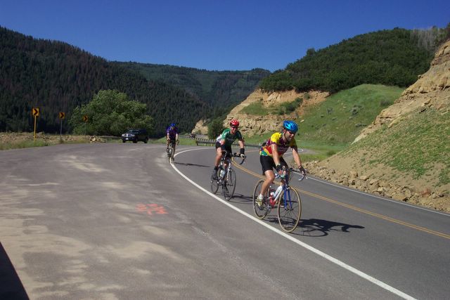
We rolled along through mostly back roads until we reached the second aid station. After that we started riding on the highway shoulder back up to Snowmass Village. At one point Kurt started riding pretty fast. I decided that I was going to take it easy on our last day, and made no effort to keep up. Hey, if the last day of the Tour de France is an easy one, why should ours be any different?

Most of the ride was spent speculating on the outcome of the Tour de France, which had started that morning. We all made bets on what position Lance was going to finish in that mornings time trial. Rick was the closest with a vote of 3rd place. Lance ended up with a close 2nd. Way to go!

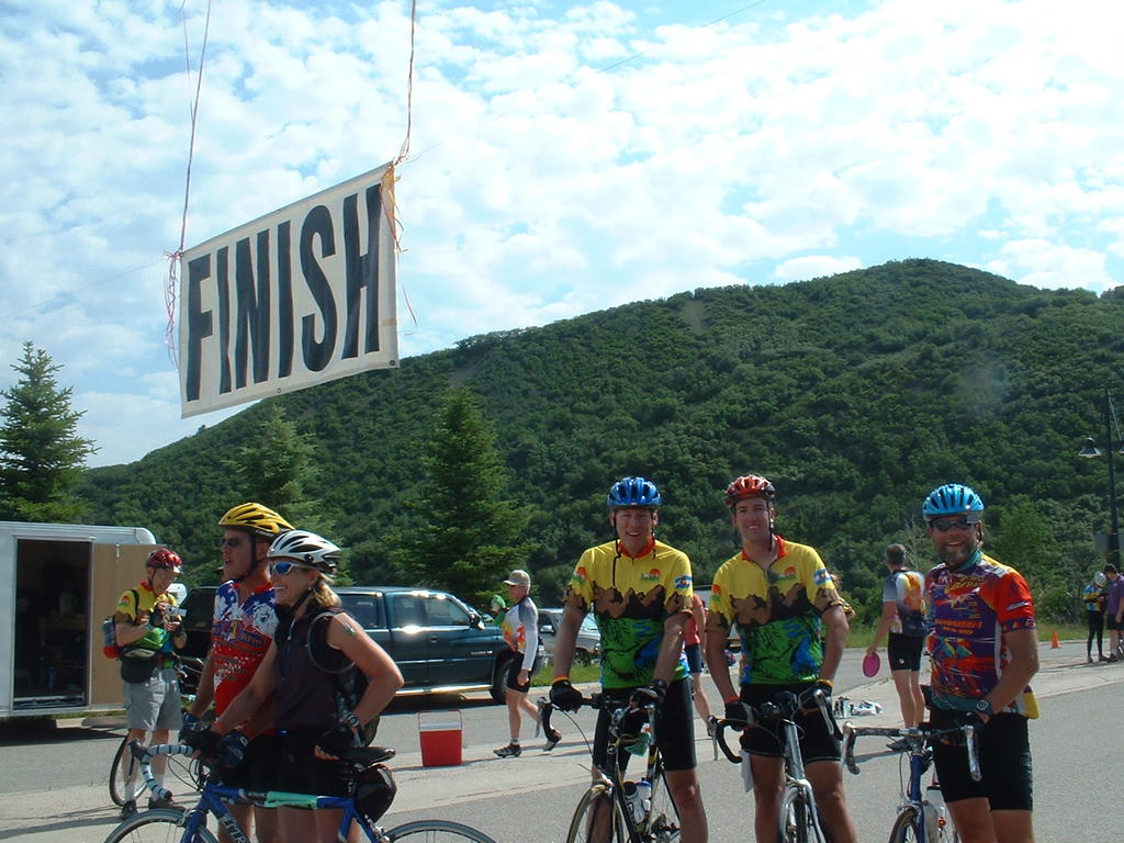
The last few miles up to Snowmass Village do get a little steep, but we held our group together well. As we got close to the top, Kurt told me to ride ahead to get a picture of Rick and him crossing the finish line. I rode hard up the hill to the finish, and snapped a picture of the "Woo Hoo!" lady as I crossed the line. This lady had been at most of the important aid stations, congratulating the riders. You could hear her shouting "Woo Hoo, Woo Hoo!" from a long distance. It was always good to see her; you knew a hard part of the ride was over.

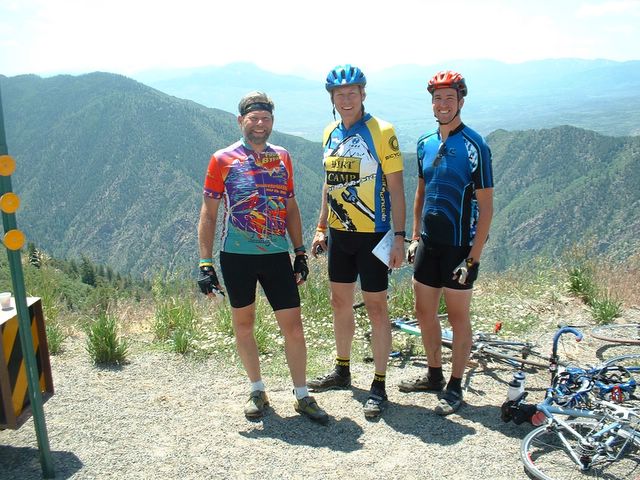
Finishing the ride was bittersweet. It was a huge accomplishment for all of us. A lot of training went into making it a successful and fun ride. But now that it was over, I had to wonder what would be next? I'm probably in the best shape I've ever been in, but without a goal to shoot for, it will be hard to maintain. It's back to the real world, trying to make some money and take care of the house. It was great to see Sarah and Maggie when I got back to the house. But now I have to make time to ride, when previously I did other things when I wasn't riding. Well, I guess that's the way it goes. I'm trying to decide whether to do another BTC next year, or try something different. Whatever it is, it will be on my bike. It will be hard to match the memories of this summer, though.

Thanks to Kurt and the Lesters for making this possible. And special thanks to Sarah for supporting this adventure. Love you!

Chris

http://www.chriswilkerson.net/maps/day7/BTC_day_7.htm
(Lots of pictures; you've been warned!)

I don't vouch for the accuracy of the climbing/descending numbers. Trip time, distance, and average speed should be accurate.

Trip Stats:
Total Distance:39.79 miles (64.04 km)
Total Time:3:09:10 (2:33:24 moving time)
Total Climbing:9488 feet (2892 m)
Average Speed:15.56 mph (25.05 kph)

Tuesday, July 12, 2005

Tour of Colorado: Day 6


Friday. This was the day that I had predicted to be the hardest. We would climb from Hotchkiss to the top of McClure Pass, about 41 miles. We were actually a little late starting that morning. The closest motel we could find was in the town of Montrose, a 45 minute drive away. I think it was about 7:20 when we left. It was a little warmer that morning, the temperature near 60 degrees.

The big thing that morning was the strong headwind that we had to battle with. It's not as noticeable when climbing, but when you get to a flat section or a downhill where you expect to be able to rest a little, a headwind can really take it out of you. Instead of coasting or easy peddaling, you have to work just as hard as you were on the climb. This is where having a goup of riders really comes in handy. The guy in front has to do the same amount of work while the others can rest a bit, but if it's done correctly no one is in front for very long. We'd change places pretty regularly, and passed many other riders. I don't know how anyone could enjoy riding this long by themself. That would be a lot of work, and boring.

The wind was getting to me a little, but not as much as for other people. I was leading our group when we went to pass this old guy. I called out "Left!" and he let out this weird grunting sound. I looked back at him as we went by. He looked to be struggling, but nothing unusual. As Rick went past, the old guy started cursing at him. He circled back on the guy intending to have some words of his own, then noticed that old guy was crying! He was saying things like "I hate this F'n wind, and I hate this F'n ride...". When Rick suggested that he try riding in a lower gear, old guy started cussing at him again. Oh well. Hope you enjoyed the SAG wagon, old guy.

We finally got out of the wind and started the climb to the summit. It wasn't too difficult of a climb, but my legs were tired from the last 4 days of riding. Kurt and I decided to ride with Rick as long as possible. As long as possible because Rick has this huge gear on his bike that lets him get up the hills more easily, but much slower. The gears Kurt and I have require you to turn over the cranks faster. If you went slower, you have to push down much harder, and tire your legs out. Anyway, we kept together pretty well for most of the climb. About 4 miles from the top I'd gotten a little bit in front of Rick and Kurt. As I went around a corner, I was some people off to the side of the road looking into the woods. I stopped and asked what they were looking at, and they said that someone had seen a bear! I decided that my Mom would really like a picture of a bear, so I got off the bike and started looking too. After about 5 minutes of looking I gave up, and started climbing again. By now, the other guys were pretty far up the road from me. I guess I wasn't going to win this hill.

The higher the hill went, the hotter it got. By the time I reached the aid station at the top, I was sweating buckets. I probably drank two water bottles once I got off the bike. It turns out that Rick was able to keep Kurt behind him all the way to the summit and get to the top first! I guess having that big gear paid off.

The downhill from McClure Pass to Redstone was a blast! It wasn't steep, which suited me, but we still went fast. I think we averaged close to 30mph the whole 10 miles. Redstone is a beautiful town. I think everyone stayed at this rest stop a little longer than they needed to, just because it was so nice.

The downhill continued for about 13 miles after Redstone, then turned into just a slight downhill grade. We rode steadily until a left turn took us on to a highway shoulder with 13 miles to go. Those were not very fun to ride. The shoulder was wide, but the highway itself was really busy and we had cars and trucks going by constantly. We finally arrived in Glenwood Springs, happy knowing that the last hard day of riding was over.

After we checked into the motel, Rick and I met Kurt at the Hot Springs Lodge & Pool in Glenwood Springs. I think most of the riders from BTC were in the pool! Here is a shot from their webcam:


http://www.chriswilkerson.net/maps/day6/BTC_day_6.htm
(Lots of pictures; you've been warned!)

I don't vouch for the accuracy of the climbing/descending numbers. Trip time, distance, and average speed should be accurate.

Trip Stats:
Total Distance:78.54 miles (126.40 km)
Total Time:6:35:49 (5:04:29 moving time)
Total Climbing:4474 feet
Average Speed:15.48 mph (24.91 kph)

Saturday, July 09, 2005

Tour of Colorado: Day 5

Thursday. Usually, the prospect of riding 100 miles all at once is kind of intimidating. I mean, that's a long way to go on a bike. I'd done it before, including the Red Canyon Century 2 weeks before BTC where we did a 18mph average. But this one had some climbing in it. A lot! But we just had a rest day, and were ready to go.

We started back in Crested Butte at (always) 7am. It was cold that morning. I think it was about 35-38 degrees when we left. For some reason, I just wore my shorts without my usual long tights over them. I guess I didn't want to get hot later in the day. Once on the road, we linked up with a few more riders, including a really strong guy who stayed at the front all the way to Gunnison. We managed to cover that in about an hour. That's pretty fast. I was also nice to know we had knocked off almost 1/4 of our total ride in an hour! Our hotel from the previous 2 nights was right on the turn we made in Gunnison, so we stopped in to visit the continental breakfast. It was by far the best aid station of the whole tour!

Back on the road, we got together with another bunch of riders and we moved along at a fast rate, almost too fast for my taste. I was having to work to keep up. We made it to the 2nd (official) aid station in less than 2 hours. This was shaping up to be a fast ride.

The next 12 miles were pretty flat and easy. We rode along some very nice lake and saw some really neat rock formations. At point we had to make a 90 degree right hand turn to ride across a dam. We made the turn, but could tell something was going on. We found out later that a rider had gone into the turn too fast, wiped out and slid into the guard rail. His carbon fiber for (part that holds on the front wheel) was broken in half, and he had broken his jaw in two places. He was lucky he hit the guard rail: it was a 200ft. drop off the other side. Could have been worse.

We started riding away from the lakes, and up into the hills. We were actually riding along the North Rim of the Black Canyon of the Gunnison. Some spectacular views that just got better the higher we climbed. The road, and climb, seemed like it went on forever. I like knowing how much further I have to go before the summit, but there weren't any signs to indicate that. We just kept riding. As we went over the top of a hill, Kurt got into an aerodynamic position and coasted down. I prefer to keep peddling, and I passed him about halfway down.

I made the turn at the bottom and started climbing, again. I wasn't racing Kurt to the top, but I really had no idea how far back he was. I started talking to this girl on the way up who also had a GPS unit on her bike. We were being real nerds, talking about software and satellites, when Kurt launched a huge attack. He went by me really fast, and I figured that would be the last time I'd see him until the summit. I started riding a little harder, deciding I wasn't going to make it easy for him. The climb wasn't a steady uphill, but had several short downhill sections. It is frustrating to work so hard on a climb just to lose that altitude and have to do it all over again.

As I got near the summit, I decided that I wasn't going to catch Kurt and that I'd just take it easy. I saw some nice views and pulled my camera out of my jersey pocket and took some pictures. These two guys behind me thought that it was funny that I didn't stop or get off the bike to take the pictures. I put the camera away and I asked them if I could ride behind them for a bit. We were cruising pretty good on a downhill when we turned a corner and I saw Kurt really hammering on the next (and last) climb. I drafted the two guys to the bottom of the hill, made the left turn, and put on the gas. I stood up, and in my big gears started trying to crank up the climb. Well, that only lasted for about 200 yards or so, and I went slowly to the summit.

It took a little while for Rick to make it to the top, but he said that it possibly had been his most enjoyable bike ride ever. He just took it easy and spun a low gear the whole way. He talked to other riders and looked at the scenery, two things that are hard to do when you are either chasing someone, or trying to get away from them.

The view from the top was great. We could look down into the Black Canyon of the Gunnison. Very cool. After we left, the climbing wasn't done. Unfortunately, the batteries in the GPS died, and the ones from the camera died soon after. I was flying blind at this point. The three of us rode together for a long while, until the downhill started and Kurt and I got away. We were riding behind this camper/RV thing trying to draft off of it on the short climbs. Rick is smarter than that so he dropped back a little. It was fun sailing past other riders, being pulled along by the campers draft. We all regrouped shortly after that for the rest of the ride. Not much to say about the next 20 miles. We took turns riding on the front, and picked up a couple of other guys on the way to help out.

We were all glad when this ride was over, and pretty impressed with ourselves. We had managed to ride the 108 miles in less than 5 hours (excluding rest stops), which is an amazing pace, especially considering the climbs we had to do.


http://www.chriswilkerson.net/maps/day5/btc_day_5.htm
(Lots of pictures; you've been warned!)

I don't vouch for the accuracy of the climbing/descending numbers. Trip time, distance, and average speed should be accurate.
Trip Stats (GPS died at 72 miles, so data is not complete):


Total Distance:72.40 miles (116.52 km)
Total Time:5:25:19 (3:48:24 moving time)
Total Climbing:14156 feet (4315 m)
Average Speed:19.02 mph (30.61 kph)

Tour of Colorado: Day 4

Rest Day!!!!!!!

After over 200 miles and 2 mountain passes, I think we'd earned it. The town of Crested Butte is crazy for bikes. There are bike racks everywhere, and people riding all over town. It's even the home of the National Mountain Bike Hall of Fame. They were hosting a bike "festival" in the middle of town. We drove down from Gunnison to see some of the sights. There are some neat little shops in town, everything from t-shirts to pottery stores. We ate lunch at a pizza place that was serving smoked barbeque on the back deck. It was good; not Kansas City good, but really good for Colorado!

One of the festival events was a bike rodeo. They had three events: a "how slow can you go" contest, a "barrel" riding contest, and a bike limbo. To win the "how slow can you go", you had to be the last one across the finish line with out putting a foot down. The "barrel" race involved riding around three trash cans. We didn't watch the bike limbo, but it is pretty self-explanatory. And no, none of us participated in any of the events. I might have done the barrel ride if they had had a tiny kids bike like we used to race around the aisles at A&B Cycle in Springfield, MO.

http://www.chriswilkerson.net/maps/day4/BTC_day_4.htm

Tour of Colorado: Day 3

Tuesday. Kurt predicted that this would be the hardest day of the tour. It wasn't the longest day. I don't think it had the most climbing. But it did end up being the hardest day.

We rolled out of Salida at 7, as usual. It wasn't as cold that morning as the others had been. The first 23 miles were all uphill, peaking at the top of Monarch Pass at 11,312 ft. Once we got away from Salida, you could see a continuous stream of riders working their way up the hill. The first 9 miles weren't that difficult, and our peloton-of-three all stayed together. After the 9th mile, the road started to get a little steeper, and the line of riders was slowing down and bunching up. Several times we had to ride around groups of 10 or more riders. The first aid station was at about mile 12, so we only got a taste of the big climb before we stopped to get some water and food. I didn't really want to stop at this one, as I finally was getting warmed up, but it was a good chance to take off my arm warmers and rearrange some gear. The temperature seemed to be going up pretty quickly, which hinted at what we had to look forward to at the end of the day.

After we left the aid station we started the getting into the real climb up the pass. Rick later figured out that Independence Pass rose at about 150ft./mile. This one, Monarch Pass, went up at about 250ft./mile. Quite a difference. We had a little downhill section after the aid station, which was a nice way to get the legs moving again. We climbed pretty steadily, ticking off the miles. At one point this guy came up behind us and was asking Rick about his "Dirt Camp" jersey. He said several things, but never got an answer. As he rode past us I said "I think he's in the zone!"

With six miles to the top I decided to test the legs. I stood up and rode away a little bit. Kurt wasn't too far ahead so I made him the target. It took a little while but I finally caught up. I think he was always a little surprised to see me appear on his back wheel. We rode together to what I was pretty sure was going to be the summit. Well almost. This hill topped out at about 10,800ft. so I knew there was a lot more to go. That and it wasn't 6 miles from where I'd seen that sign. More like 1.5 miles.

I had to work pretty hard to stay on Kurt's wheel. He kept getting little gaps on me which I had to keep from turning into big gaps. We finally got close to the top, and I stood up to stretch my legs. As I peddled, my legs felt better and better, so I kept upshifting gears, and went faster and faster. I didn't realize how close to the top we were. We made a turn to the right and I saw the people at the aid station. I upshifted again and cruised to the top.

After the aid station, we had a long (12 miles) downhill. There was construction being done on the road, and some of the lanes were closed. We went down about a quarter of a mile and had to stop and wait for oncoming traffic to clear. The guy holding the stop sign was really nice, and joked with the riders. When we were allowed to go, it was a free-for-all. No matter how fast you were going down the hill, there was somebody going faster. I usually try to keep my speed under about 40mph, so Kurt and Rick got a pretty big gap on me.

The next 25 miles or so were pretty boring, flat with a bit of a headwind. When we arrived at the aid station in Gunnison, we saw lots of people putting their bikes on the SAG wagon. This is a van with a trailer for hauling bikes that you can ride if you get too tired, injured, or have a technical problem. Most of these people were just tired of fighting the headwind and decided to make it into a Van Tour of Colorado. From the first day of the trip up Independence Pass, to the last day back at Snowmass, we saw some disabled riders using hand powered bikes. Imagine riding up a mountain pass with just your arms to get you to the top. I told Rick that after seeing these guys and girls doing this that there was no way I could ever wimp out and take the SAG wagon.

The headwind only got worse as we rode out of Gunnison toward Crested Butte. Our hotel that night was actually in Gunnison, but I wanted to finish out the ride. The road started going up also, from about 7700ft. in Gunnison to about 8900ft. in Crested Butte. At one point we had a really strong cross-wind, and it threatened rain. About 3 miles from town it looked like we had an easy downhill to the finish. This guy that we'd grouped up with (there were 8 or so in our group now) started cheering. He wasn't cheering when we started climbing again. When we actually could tell we were close to the finish line, he started cheering again, louder than before. I would have, but I was thuroughly cooked. We'd been riding for well over 6 hours, and I was ready to get off my bike. At the "bike village" where the campsite was, a local business was selling massages. Rick treated himself to one while I went hunting for schwag (free stuff).


http://www.chriswilkerson.net/maps/day3/btc_day_3.htm
(Lots of pictures; you've been warned!)

I don't vouch for the accuracy of the climbing/descending numbers. Trip time, distance, and average speed should be accurate.
Trip Stats:

Total Distance:91.58 miles (147.38 km)
Total Time:6:30:23 (4:47:38 moving time)
Total Climbing:17425 feet (5311 m)
Average Speed:14.76 mph (23.75 kph)

Wednesday, July 06, 2005

Tour of Colorado: Day 2

Monday. We started again at 7am. This was a day we were looking forward to. 58 miles, all downhill. From 10,000 ft. to below 7000 ft. and only 2 minor hills. Not much to say about this stage except it was fast. We grouped up with this guy from Texas and his son. The Kid (as we called him) dressed head to toe in matching attire. It would have been funny if he hadn't been so fast! We all took turns leading the group, looking very professional! (This is known as a paceline. The guy in front goes hard and blocks the wind for the guys behind him. This lets the others rest a little, and keeps the speed high. In fact, the guy in the back can go the same speed as the guy in the front without hardly peddling at all).

We stopped at a few rest stops, and then took off again. The only nervous part was right after one of the rest stops. The road had just been repaved with chip-and-seal, which is basically gravel. We had about 5 miles of riding in this stuff, which brought down our average speed. Lots of people were getting flats in this section. Luckily, none of us did. In fact, neither Kurt nor Rick nor I had a flat the whole tour! Good luck was with us.

With about 5 miles to go it was my turn to take a pull at the front. I usually try not to stay in the front for more than about 5 minutes at a time. But when I got up there, I saw another organized group of riders in the distance. I made catching them my goal. I went really hard, but always careful to make sure that I didn't drop anyone from our group. I finally got to within about 50 yards of that other group. They were moving pretty good, too; it took about 3 or 4 miles to catch them. I pulled off the front and let Rick finish the job. I think they were surprised to see us go flying by. They got on to the back of our group just in time to roll into town.

We intended to not go so hard today, with a big day coming up on Tuesday. But when you are having fun, sometimes it's hard not to see what you can do.

http://www.chriswilkerson.net/maps/day2/BTC_day_2.htm
(Lots of pictures; you've been warned!)

I don't vouch for the accuracy of the climbing/descending numbers. Trip time, distance, and average speed should be accurate.

Trip Stats:

Total Distance:58.43 miles (94.03 km)
Total Time:3:32:16 (2:37:33 moving time)
Total Climbing:4096 feet (1249 m)
Average Speed:22.25 mph (35.81 kph)

Tour of Colorado: Day 1

Hi everybody. We got back from our tour on Saturday, and I've been working on some webpages to illustrate where we were and what we did. I'll post a link for each day at the end of each post.
We drove up to Snowmass Village on Saturday, June 25. That was when check-in was happening. There were lots of bikes everywhere. Amazingly, the check-in went very smoothly. I figured with about 1500 people trying to check-in at the same time, we'd be standing around for a while. We had dinner that night, and then went to bed. People decided that in front of our window was the perfect place to party, so sleeping that night was kind of difficult.

We decided that 7:00am was the appropriate time to start riding, so, to get breakfast cooked and eaten, we were up at 6am. It might have been earlier; I can't remember. We brought a toaster with us and I ate waffles, a bagel, and some Ensure. That makes for about 1100 Calories. Good Times!

The ride started with a difficult climb right out of the parking lot. It wasn't that steep or very long, but without any time to warm up, the legs were feeling pretty stiff. After that, we coasted down into Aspen. It's a nice little town, but I don't see what all of the fuss is about. I guess it's because it is close to the ski hills.

After we made it through Aspen, the climb up Independence Pass began. This is roughly 20 miles of climbing, starting at about 8000 ft up to over 12,000 ft. It actually wasn't that bad of a climb, but I like climbs. Several people that we passed by might disagree. When we were nearing the top, I saw Kurt (who thought he was going to drop me on the climb, Ha!) talking to this guy who was riding a unicycle! That was pretty cool to see. He says that the hardest part is riding down the hill.

The 3 of us made it to the top of the pass within a few minutes of each other. It was really rewarding to see the sign at the top showing the elevation (12,095 ft.). Everyone was snapping pictures and getting a bite to eat at the top. I'm pretty sure I burned off my breakfast about halfway up the hill.

After we refueled it was time to ride down the other side of the pass. I like climbs; I do not like downhills. I'm a wuss when it comes to going down hill. It was much colder at the top of the pass than in Snowmass, so we "kitted up" with armwarmers and vests. We started down. It's amazing how fast you can pick up speed on a light bike and a steep descent. There were several times that I exceeded 40mph. On these long downhills, it is important not to ride the brakes the whole way down. You quickly wear out brake pads, and can actually heatup the wheels enough to pop tires. I stopped after a few switchbacks because I was getting cold and freaked out. Rick stopped with me and we shot some pictures. We rode down a bit more and were still cold. We stopped and put on our plastic rain jackets. Usually we avoid putting these on because they just trap heat inside like a sauna. But for the downhill they did a good job of keeping the wind off.

We finally got to the not-so-steep downhill section, and zipped along at 25-30 mph. Rick almost had his head knocked off by "Truck F." It was one of the tour support vans that decided to pass us at a very dangerous time. Luckily no one got hurt. It was a un-eventful flat ride for about the next 10 miles until the rest stop. We stopped and grabbed some food and water, then set off again. We tried not to stay at the rest stops for very long; your legs tend to tighten up so that when you get moving again, then feel really stiff and heavy.

There were only 16 miles to go at this point, so we figured it would be an easy hour to the finish. After about 5 miles a vicious cross-wind kicked up. It was probably a sustained 35-40 mph, with 50-60 mph gusts. This makes it hard to stay upright, let alone keep any kind of speed. A few miles later, the wind dropped a little, but then the rain started. We aren't sure if it was sleet, or just hard blown rain. Whatever it was, it stung! Kurt stopped to put his rain jacket on, and I passed him. I'd taken mine off before the rest stop, and didn't feel like stopping to put it back on. I was already wet; I wasn't going to get any wetter. I pushed on through the rain until the wind stopped. People from the tour were pulling off of the road left and right, trying to find shelter. I just kept going, actually really flying at some points. No body passed me the rest of the ride. When I finally got to Leadville, the sun had come out and I was pretty dry by the time I reached the end of the ride. Except for my shoes and socks. Those were still really cold and wet. When Rick showed up a few minutes later, we decided to go to the local Pizza Hut and get some lunch. That really hit the spot after a long day.

http://www.chriswilkerson.net/maps/day1/btc_day_1.htm
(Lots of pictures; you've been warned!)

I don't vouch for the accuracy of the climbing/descending numbers. Trip time, distance, and average speed should be accurate.

Trip Stats:
Total Distance:64.87 miles (104.40 km)
Total Time:6:30:23 (4:47:38 moving time)
Total Climbing:14252 feet (4344 m)
Average Speed:13.53 mph (21.78 kph)

Chris and the Tour of Colorado

Hello! Chris has been working hard to put together a really cool post to tell you all about his trip. It is taking a little while to prepare, but it will be worth it, I promise! In the meantime, I posted some pictures of Chris, my dad, and Kurt (a guy we go to church with who went on the trip). Everyone had a wonderful time, and Chris is so tan and skinny now! He has all kinds of funny bike tans. You can see where his bike gloves have been, and there are strap marks on his face from where his helmet was. Maggie and Rosie and I are so glad to have him home again. We have started watching to Tour de France on TV. Lance and his team are kicking butt so far! We have 2 and a half weeks left so think some good thoughts for him! Look for Chris's post soon!

The first picture below, Kurt is in the lead, then Chris in the green jersey and then my dad.


Racing along the mountain


Kurt (guy from our church), Dad and Chris


At the top of Independence Pass


Day 1